The Dolores: My way.

It would have been sometime around 1979 or 1980. I left from my house on Darley, so buying that house (my first) marks the early limit, and construction on the dam, which was definitely not going on when I ran, marked the latest limit.  Work on the dam started in earnest in the fall of 1980, with construction of the river diversion.  I think I can figure this out, someday.

El Rio de Nuestra Señora de Dolores, River of Our Lady of Sorrows.  The greatest sorrow for the river, and a great sorrow for me, was coming.   I knew I needed to run this river before they built the dam.  I needed to run it through the “take area” and, while I am at it, I should run it to its mouth.  I knew I didn’t have much time.  No one else wanted to go just now.

And now, the end is near,
I’ll do it my way.

That was, without a car.

I caught a ride to the FibArk slalom race with my housemate Linda Hibbard. I raced, though I have no recollection of how it went. This may have been the year I paddled almost solely C-1 (for a new challenge). If so, then I finished third (as I recall), which was probably also last. There were not a lot of C-1 paddlers in CO.

After the race I caught a ride to Durango with another racer. Can’t recall who, but it was one of those guys who beat me regularly. That is, a good slalom racer. I hauled my touring boat and paddle, and all my gear (pretty lean); Linda took my racing boat and paddle back to Boulder.

I remember that I stayed with Pres Ellsworth, a river outfitter, in Durango. I met Pres through opposition to the Dolores project, and probably also opposing  the Animas La Plata Project. I probably would have gotten together with the ALP women, led by Jeannie Englert, but I think that by then Jeannie and Tim might have moved to Lafayette.  Both efforts at opposition were futile but worthwhile.

So far, so good, but the really good stuff was about to begin. The next morning, Pres dropped me off on CO160 on the west edge of Durango. I stood there with my huge Lowe Expedition pack, kayak and paddle for…not very long.  Amazingly,  I had only been standing there a short time when an orange-ish VW van with a family going to Mesa Verde stopped and picked me up. Recently, I think I found a vestige of that ride–a note or something that I connected by inference–with a name. (Maybe somewhere there is a journal, but I was not good at that. And, I didn’t take a camera–maybe the Olympus XA had not yet come into my life as a camera I could carry in a ziplock bag.)  Maybe someday I will figure this out, too.

The family in the orange-ish van dropped me off at the exit to Mesa Verde. It was an exit–two-lane 160 expanded into four lanes for a short time, so rather than battle across oncoming traffic from a left turn lane, you could exit and go under the highway–very deluxe, and probably the same structure that is there now, but embedded in miles and miles of four-lane roadway.

I’m still not sure what prompted me to do it, probably that traffic was sparse, this being a Monday (Slalom races ran on Sunday; course setting and practice was on Saturday), but I ran (sort of) up the ramp, toting my boat on my shoulder and my pack on my back. I didn’t want to miss a car, even though the odds were low that anyone would pick me up. My idealized memory is that the first car stopped, and that fits into the serendipity of this trip, but that’s probably too good to be true.  In any case, I did not wait long until a young fellow stopped. A teenager, high school age as I recall. He lived in Dolores! That’s my put-in.

My plan only went that far–I did not know for sure where or when I’d sleep. I probably had Plan A, Plan B and Plan C. A being an afternoon launch and camping down the river a ways. B would have been staying in or around Dolores, and C would have been back on 160 somewhere.

The Kid worked at the Pizza Hut in Cortez, and he was going to work. He told me he would take me down to Dolores after he got off work, sometime in the evening. So, Plan B it was. I remember going to a movie and then going to the Pizza Hut to eat, and to leave a tip. l probably left my boat and gear on The Kid’s car. God, do I wish I’d had a camera to boost my recall. That evening, The Kid dropped me at the park in Dolores with assurances that the sheriff would not roust me.  The next morning I ate across the street and set off.  It was roughly 200 miles to the confluence with the Colorado, only a little shorter distance than the usual run through the Grand Canyon.

I had little gear–probably no tent, just a tarp, a very light, compact down sleeping bag, stove, one pan and a water bottle.  Filip and I pared down gear when we ran the Chixoy-Rio Negro-Salinas-Uscumacinta a couple of years before.  It all fit into three or four large heavy plastic bags, which in turn fit into light, ripstop nylon bags (enormous stuff sacks, I had made).  The Lowe pack went behind the seat.  All the bags would fit into the pack, so a portage involved jumping out of the boat, pulling the pack, stuffing the bags into the pack, shouldering that and the boat and tottering off, using the paddle for balance.  I didn’t plan to portage anything on this trip, but Filip and I had finely choreographed the portage in Guatemala.

There were several landmarks on this trip.  The first was Bradfield Ranch, the usual put-in to run the Upper Dolores.  Next was Snaggletooth Rapid.   There were more, but this day all that counted was Bradfield Ranch and Snaggletooth.  I had no idea how many river miles it was to either.  Nobody ran this upper-upper stretch, and there were no maps.

Probably there was a map–somewhere the Bureau of Reclamation had a mile-by-mile map of the river that showed all the dam sites.  I didn’t have this, though.  The only map I had was a Xerox from a EIS on something like oil development, which showed the lower river, from somewhere near Snaggletooth to Bedrock, where it enters the Paradox Valley.   That is, it covered the Slickrock to Bedrock run, AKA the Lower Dolores.   I was running past there, to the Lower-lower Dolores, and on to the Lower-lower-lower Dolores and to its confluence with the Colorado River, just above the departed and much-missed Dewey Bridge.

I knew from reports that I could run the river all the way from Bradfield to the confluence, but there was Snaggletooth.  The rapid was described with respect–Ron Mason had once carried it when he ran the Dolores in a wildwater boat–but by now I had been kayaking seriously for five years or so and I’d run the Grand Canyon two or three times and much class IV and even V water.  I was not concerned.   Mason was a ninja, but he was in a long and tippy wildwater boat.

Snaggletooth was no factor the first day.  As I am wont to do I probably lingered over breakfast and coffee, getting a late start, and the river mileage was longer and the gradient lower than my idealized notion.   I stopped somewhere above Bradfield Ranch, I really didn’t know where.  The next morning, I got an earlier start and set off.  Perhaps I stopped at Bradfield–I don’t recall–but my mission was to get to Snaggletooth.  That that was my mission does reveal that I was at least paying respect to the rapid.  I was really probably anxious about it, as it was an unknown, and Mason had walked.

I said to myself that I would stop and pee when I got to Snaggletooth.  Maybe I was planning to get out to scout it, rather than scout it from the boat, or maybe this was an excuse to allow me to get out without admitting any weakness.   Anyway, I stayed in the boat and paddled onward below Bradfield. And I paddled and paddled and paddled.  I’d run a number of sharp but not stressful rapids, and I’d gone what felt like a long way.  I should have been to Snaggletooth by now, and I really had to pee.  I convinced myself that Mason had had a weak day and that I had passed the rapid, and I got out and peed.  But, it’s easy to overestimate how far you’ve traveled on a river in a narrow canyon, and I am an optimist.

Snaggletooth, in its reality, is no-shit rapid.  It’s equal to rapids on the Selway.  That’s the first impression I had when I came around a sharp corner and heard the roar.  There is no option to scout from the boat, at least at the water level that day–there is a horizon line, and big splashes come above it from a surging hole below.  That’s the style of approach you have to big rapids on the Grand Canyon.

Scouting big rapids leads to two states–tranquility or bowel-loosening vigilance.   There are three ways to get to those two states.  Category 1: At your first glance you see that the rapid is easy.  Category 3: At first glance you see that it is clearly unrunnable.  Like most things in life, it is the middle, uncertain situation where the hard decisions must be made.  Snaggletooth fell into Category 2: clearly runnable, but demanding a near-perfect run.  That day, for me, then, it fell into Category 2.  Now, for me, very likely, almost certainly, yes definitely, it would fall into Category 3.

The run was not notable.  At least, I don’t have any recollection of it, so I infer it was not notable.  No missed strokes or miscalculations.  No rogue waves, flipping me over or surfing me to the hole formed by the snaggletooth rock.  I’m sure I was exhilarated.  Jubilant.  Relaxed.  More odd serendipity was around the corner.

Not far below Snaggletooth, the Ponderosa Pines appear at river level, and the Dolores begins to embed itself into the massive Wingate sandstone.   Quite suddenly it feels like a desert river.  It’s no coincidence that the next road crossing is at the town of Slickrock.

Very near Snaggletooth–memory fails, but the circumstances dictate “very near”–I was paddling lazily along, probably looking for a place to eat lunch.  I was along the right shore when I saw something bright on the river bottom.  The Upper Dolores watershed is reasonably mature, so the upper river is clear–its gradient and water are somewhat reminiscent of the Middle Fork of the Salmon.  Not crystal clear, but pretty darn good.  That would change downstream, but right now, on the receding limb of the hydrograph, I could see the bottom, and there was something odd there.  I paddled over and reached down, still in my boat, bracing myself with the paddle. Aluminum.  More brushing, more aluminum.  Digging.  More aluminum.  I got out of the boat and dug more.  A big, flat surface.  A rounded edge.  It became apparent as a very large commercial saute pan.   I found a handle and pulled it out.  That stirred up a lot of mud, but not so much that I could not see another, nested pan.  Pulling that one out revealed another, and then another.  Four in all.   Some commercial rig had flipped in Snaggletooth on the high water, and here was where the inadequately stowed frying pans finally fell off the inverted raft.

Damn do I wish I had a selfie of me and those crazy frying pans.  But, I still have three.

Three of the frying pans I found below Snaggletooth. I gave the fourth to Mary Margaret Golten

One of the central problems of my personality is the feeling, about just about anything, that “this might come in handy some day”.  I’m sure this is a residual of parents who lived through the Great Depression.  When we cleaned out their house after Mom died, we found a drawer half full of rinsed, dried and neatly smoothed and stacked plastic bags.   The frying pans were clearly going to be mine, but the question was, how?  By now I was within the domain of my Xeroxed map.  I could see that a side gulch a few miles down led, with a climb of a couple thousand feet, to a place on the rim where an old uranium road came near.  So, I sat the pans on my lap and paddled on.  The road was there, just as my map said, and I stuffed the pans into a rock cavity and covered them up.  I took a good look at the details and walked back to my boat.   I would be back, but it would be years.

Where I went next I don’t recall.  Downstream, of course, but how far escapes me.  I probably passed Slickrock and camped.   Slickrock is the normal put-in for the Lower Dolores–its the first bridge below Bradfield–but no one was there that day.  I doubt I worried much, because I would be returning from the Dewey Bridge on Utah 128, along the Colorado River, and the usual river runners would offer no logistical advantage.  In fact, it might have been a bad thing to run into another trip there, because they would very likely have been getting out at Bedrock, and I would have been tempted to join them.  (I might have been able to snag a beer or two, though.  Beer was not in my spare commissary.)

The next place I remember is just inside the entrance to the Dolores Canyon on the downstream side of the Paradox Valley.   It’s a paradox because the Dolores flows across the valley, cutting into the valley through one wall and out of the valley right through another.  These are Wingate walls–cliffs–so the entrance and exit are spectacular.  The river was probably once superimposed on a rising dome, in a continuous set of meanders, but then the underlying salt collapsed forming the valley, and the river stayed on its course.  There was no other way to go–either end of the valley is up hill.   The river’s exit from the valley is dramatic, and it promised nicer camping than in the cow-pulverized, shit-strewn, unsheltered valley bottom.   Shortly after I turned the corner I hunkered down below a cliff and out of sight of the road that ran along the river.  Serendipity was about to strike again.

The Y11 road above my camp ran from CO 90, just east of Bedrock, across the floor of the Paradox Valley, and along the Dolores to the mouth of the San Miguel River.   Y11 had been used to haul uranium ore from mines on the exposed strata of the north rim of the Paradox Valley, thence up the San Miguel to Uravan, where there was a notoriously dirty mill.  Uravan is now just a site, with just a couple of buildings standing.  They may be off limits.  At the time I passed through, the mill at Uravan was running, as it had since the early parts of the 20th century.  It began refining radium ores, and then switched to uranium ores in support of the Manhattan Project, and during the cold war.  It was a sloppy, grown-like-topsy operation, and much radioactive contamination escaped and was left.  Eventually, it was cleaned up, as much as is possible, through the Superfund program.   In the oughts I worked as an expert witness on litigation between residents of the company town and Union Carbide.  Gerry Spence was the plaintiffs’ attorney.

After the Y11 road turned up the San Miguel, the Dolores Canyon looked untouched for a bit, but in a short distance the remains of the Hanging Flume came into view.   I’d forgotten about this, so it was a bit of a shock.  The flume carried water from high up the San Miguel and then along the Dolores to alluvial deposits of silver, preserving enough head to allow for hydraulic mining.  It’s a crazy thing–it clings to the sheer Wingate walls.  Now it has been restored in reaches, but then much of the remains were fragmentary.   A little bit further CO 141 comes into view.  I’d crossed under 141 at SlickRock–It begins in Dove Creek and then takes a big, S-shaped route, first eastward, then back westward to the Dolores, following it to Gateway.  When the Dolores turns west and cuts its way between Steamboat Mesa and Polar Mesa to the Colorado, highway 141 heads northeast, up Unaweep Canyon to  Whitewater, along Highway 50, just south of Grand Junction.  A geologic instant from now Unaweep Canyon will capture the Gunnison, confounding Colorado Water rights holders.

The Dolores Canyon along 141, from the San Miguel to Gateway is national-park spectacular.  Like UT 128, there are parts of the road that rival Zion.  The road is an unwanted intrusion onto the river, but in those days it had little traffic, so you could mostly ignore it.

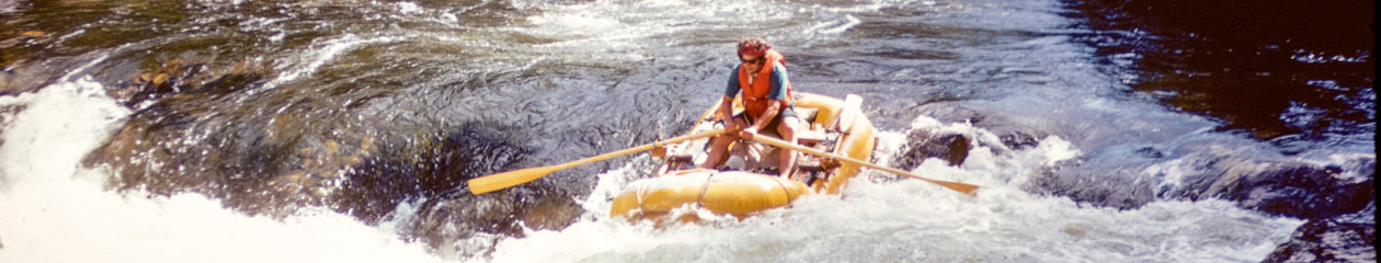
Sometime that day, below the San Miguel, I came around a corner and saw a couple of rafts.  They were small below the vast Wingate cliffs, but they were very interesting to me.  No one ran this stretch–what were they doing there?  As we approached there was a moment of puzzled half-recognition.   Did I know this guy; he was asking himself the same question.  In a moment, replacing the context, I recognized Tom Bryant, a young hotshot kayaker from Boulder.  We had paddled together only a couple of times, but kayaking in those days created tribal bonds.

Tom, it turns out, had organized this raft trip for a bunch of friends  to run this lower-lower canyon of the Dolores precisely because it is seldom visited .  Wonder of wonders, lightning strike of serendipity, they were going on to run the lower-lower-lower canyon from Gateway to Dewey Bridge.  Here was my ride home.  To my front door in Boulder, as it turned out.


Captain’s Log, March 23, 1916

Stamp issued by Great Britain's Royal Mail on January 7, 2016, honoring the centennial of the Endurance Expedition.  Frank Hurley on left, skinning a penguin; Sir Ernest Shackleton on the right.
Stamp issued by Great Britain’s Royal Mail on January 7, 2016, honoring the centennial of the Endurance Expedition. Frank Hurley on left, skinning a penguin; Sir Ernest Shackleton on the right.

‘Land in sight’ was reported this morning.
South!, Sir Ernest Shackleton.

The land sighted on March 23, 1916 was the ragged ridges of Joinville Island, and it was the first land the Endurance crew had seen in sixteen months.  They had been on the ice since October 27, when Endurance was crushed, living in rotting clothes and eating seal meat, their dogs, and even the undigested fish found in the stomach of  a leopard seal.  In very cold weather, each man got an extra ration of seal blubber.

Moving across the ice was not impossible, but it would have meant sure death by exhaustion, given the jumbled, broken surface.  This they had learned by bitter experience.  So, there was nothing for them to do but stay alive and wait for the slow gyre of ice to move them to it’s edge.  How did they all not go crazy, just waiting?

They passed the autumnal equinox, the beginning of winter, in a fierce blizzard–surely taken as a warning that time was running short for an escape.  When the blizzard relented, the weather turned bitterly cold, and then stormed again.

In our weak condition, with torn, greasy clothes, we felt these sudden variations in temperature much more than we otherwise would have done. A calm, clear, magnificently warm day followed, and next day came a strong southerly blizzard. Drifts four feet deep covered everything, and we had to be continually digging up our scanty stock of meat to prevent its being lost altogether. We had taken advantage of the previous fine day to attempt to thaw out our blankets, which were frozen stiff and could be held out like pieces of sheet- iron; but on this day, and for the next two or three also, it was impossible to do anything but get right inside one’s frozen sleeping- bag to try and get warm. Too cold to read or sew, we had to keep our hands well inside, and pass the time in conversation with each other.

“The temperature was not strikingly low as temperatures go down here, but the terrific winds penetrate the flimsy fabric of our fragile tents and create so much draught that it is impossible to keep warm within. At supper last night our drinking-water froze over in the tin in the tent before we could drink it. It is curious how thirsty we all are.”South!, Sir Ernest Shackleton.

By now their sextant showed that they had drifted north of Paulet Island–it, and the stocked hut on it, were now out of reach–and they had no hope of crossing the sixty miles or so of rugged ice that separated them from Joinville Island, which they were now drifting past.

For the next two or three days we saw ourselves slowly drifting past the land, longing to reach it yet prevented from doing so by the ice between, and towards the end of March we saw Mount Haddington fade away into the distance.

Our hopes were now centred on Elephant Island or Clarence Island, which lay 100 miles almost due north of us.

If we failed to reach either of them we might try for South Georgia, but our chances of reaching it would be very small.
South!, Sir Ernest Shackleton.


Creepy?

In a classic piece of ethnography from the 1940s, William Whyte carefully watched the interactions among Italian immigrants on a street corner in Boston’s North End.  Technology today has made the world like the street corner in the 1940s—it is now possible to make detailed observations on the behavior and interactions of massive numbers of people. These observations come from the increasing  number of digital traces left in the wake of our actions and interpersonal communications.
Mobile Phone Data for Inferring Social Network Structure, N. Eagle, A. Pentland & D. Lazar (pdf)

After several years of futile resistance I was assimilated by Facebook this week.  Ultimately, I decided that I wanted to keep in touch with friends, many of whom I’d lost contact with over the years.   I finally overcame my concern that I would come to know too much about some of them.   I get friend requests as my “circle” expands.  At this writing, I have twenty four friends.   FB also suggests “People you may know.”

Sometimes those suggestions can seem a little too good.  Caitlin Dewey wrote in the Washington Post last spring about how Facebook does it.  In Dewey’s telling, it’s all good math.  But, just how paranoid should I (we) be?

Last night I went to a very small party, where I met Jean for the first time.  This morning FB suggested Jean as a person I may know.    Dewey’s “good math” explanation would have that suggestion be the result of matching information from our profiles and our network.  But, my profile discloses nothing more than where I live (Boulder, Colorado) and where I went to school.  Jean’s profile has not much more.  We have no mutual FB friends.  We have no mutual FB interests (I have disclosed no interests to FB explicitly.)  I have not allowed FB to see my contacts.   It would actually make more sense for FB to suggest Jean’s husband, with whom I worked briefly in an exotic location, though not within the same organization.

So, is the timing just a coincidence, or did FB know or infer that we were at the same location last night?   I have installed the FB app, but I have turned off the location option (at least that’s their story).   Or, does FB know that I searched for the party address on Google Maps shortly before I left my house last night?  Did Jean do the same?

Association by proximity is ho-hum.  FB offers opt-in proximity alerts in its Nearby Friends service, but wondering about PYMK is a small industry on the internet and a few folks have seen evidence that physical proximity prompts PYMK suggestions.  But FB does not have permission to use my location, and in 2014 they denied that they use location data for PYMK (though the wording is such that FB could deny the denial if they are caught actually using location info).  Is FB inferring proximity from other information?  I don’t know.  I don’t know, but I am going to do a little experiment.

From OpenBeacon.org. This is really just eye-candy, since it was developed using an active-sensor approach.
From OpenBeacon.org. This is really just eye-candy, since it was developed using an active-sensor approach.  It’s a neat visual, though.

Let me offer up an idea I had several years ago that is even creepier–it is completely passive and there is no opt out.  It was such an evil idea that I thought about patenting it, but intelligence agencies are probably already doing this, so going through the expense and brain damage of applying for a patent would probably be a waste of time (and a source of trouble.)

Radio Frequency Identification (RFID) is a technology where a small transponder transmits an identification code upon interrogation by radio.  There are a variety of technologies, but some are small enough and inexpensive enough to be placed in clothing.  I have an RFID transponder on my car that allows automatic tolling on a nearby highway.  The RFID unit is a small windshield sticker that replaced a cell-phone-sized active, battery-powered transponder.   Passports issued since 2007 have an RFID transponder, as do many new credit cards.  There are real concerns about privacy with RFID, so standards have been developed that are intended to protect your identity from nefarious interrogation of a transponder.

But, as RFID tags used for inventory control become smaller and more common, even ubiquitous, the combination of RFID codes in the collection of clothes a person is wearing will provide a practically unique signature.   A particular RFID code is not necessarily unique, but a combination of several codes becomes virtually unique.   Of course, people will wear different clothes from day to day, but it is not difficult to imagine a data mining approach that would categorize different sensed combinations as being the same individual–I have not done the math, but detecting even two codes together would likely be a very  reliable signature.   Of course, once a set of signatures has been associated with Person X, then that individual can be tracked, and can be associated with other people by proximity in space and time.   RFID interrogators placed in airports, train stations, bus stations or even on streets or in shops, could provide a rich data set from which associations could be inferred.  Figuring out who Person X really is will not be too hard.

If you think this is far-fetched, take a look at what Disney is doingJust replace “object” with “person”.

What makes this seem particularly evil is that it is not opt-in, and you cannot opt out.  (Though you may be able to destroy RFID tags in your clothing (using a microwave oven–look it up), you won’t be able to do that with electronic equipment, your passport or your credit card.  Some technologies that vary returned codes according to an algorithm known, in principle, only to the manufacturer could also make social network discovery through RFID more difficult, but only if used in all RFID transponders.)

You are probably not crazy if you are a little paranoid about all of the information you are leaking.  My advice for your peace of mind:  Don’t try using face recognition in Picasa or Google Photos (or now Lightroom).  It’s creepy good and sometimes scarily wrong.


Prime Time

In the beginner’s mind there are many possibilities, but in the expert’s there are few.Shunryu Suzuki, Zen Mind, Beginner’s Mind: Informal Talks on Zen Meditation and Practice.

Farhad Manjoo has an interesting article about Amazon in today’s New York Times.

(Disclaimer:  I don’t know anything about retail.  Or, wholesale or fulfillment or a wide variety of other aspects of business.  I’m just kibitzing here.)

It is Jeff Bezos’s patience that has been the key to Amazon’s rise to dominance in online retail, at least according to Manjoo.  And, I won’t argue with him because lack of patience, the obsessive focus on the current quarterly performance, was one of my big complaints during my seven-year tenure at a multinational, publicly traded firm.

The value of Amazon’s shares doubled in 2015.  This was not supposed to happen according to skeptics of theJeff Bezos’ huge investments in infrastructure.  Some critics will still say that it was the lucky move into web services that has fueled Amazon’s recent success, and it is true that Amazon Web Services has become huge–Manjoo reports that AWS will soon be worth more than Intel.

But, the retail business is profitable, and Manjoo says it has passed the “inflection point” where the company’s investment in more than 100 warehouses, along with other “fulfillment” infrastructure, has begun to pay off.  Sales growth now requires little additional investment.  And, some are projecting a lot of growth.   Manjoo writes that one analyst forecasts that by 2020 over 50% of U.S. households will subscribe to Prime, Amazon’s subscription and free-shipping program.

It is Prime that looks to drive Amazon to retail dominance in the U.S. and elsewhere (Alibaba in China dwarfs Amazon.)   In retail, Prime harnesses the “power of free”, described by Dan Ariely in Predictably Irrational ($19.39 at this writing on Amazon.  Eligible for Prime.)  Both Dan Ariely and I benefited from the power of free as I described in this e-mail.

Whatever the reasons for its success, Amazon’s dominance causes concern, primarily among its competitors, but also on the part of local “bricks and mortar” retailers.

Our household is a Prime subscriber, and I purchase stuff from Amazon.  I do like shopping at local businesses, and I am concerned about how Amazon’s ascendancy might harm them.  But, is there a way that Amazon could help local businesses?

From time to time I will run into Dave Hite at McGuckin Hardware.   Dave and Dee (McGuckin) Hite own the store.  I’ve been shopping at McGuckin’s since it opened: Dee’s brother Ron was a schoolmate at Boulder High School.   I even did a little bit of manual labor for the store way back when.

Dave and his family have been in hardware for a long time, and what says is his biggest concern is the decline of wholesale suppliers to independent hardware stores.  The big operations have their own supply chains; as their lower prices lead independents to close, their suppliers also weaken or disappear, which in turn pushes more marginal retailers into failure.  This is a positive-feedback condition, aka “progressive failure” or “death spiral”.

Now comes Amazon, with wholesale buying power and fulfillment that is unrivaled in the U.S.  Amazon already provides a complete warehouse and fulfillment service to small internet sellers–carefully package and label your stuff, ship it to Amazon, and where it is stored until they ship it according to your instructions.   Why can’t this model support local businesses.  Say that Amazon expanded its business to include a comprehensive collection of hardware.  A shopper at McGuckin Hardware who could not find what they want in the store would browse the Amazon stock with a store clerk and order what they want, using McGuckin’s “mega-Prime” account.   Amazon and McGuckin each get a cut and the customer gets what they want delivered to their door.   I dunno, maybe this is dumb, but it seems like an interesting  possibility.  I’ll raise Shunryu Suzuki on this.

The other thing that I wonder about Amazon is how the delivered transportation energy cost of an item compares to one picked up from a local store?   I don’t know the answer to this, but I think there’s a good chance it would go in Amazon’s favor, particularly when you consider that the product is hauled home from the local store along with multiple tons of vehicle.   This seems like an interesting question;  perhaps it has already been answered.


Hakkapeliitta, Cyo Senso and the Dynamo

2015-11-16 16.29.58.WPI’ve been a transportation cyclist for 40 years.   Of course, until a couple of years ago I was a commuter, then I discovered the new terminology.   I ride year-round in Boulder, Colorado.   For those of you who know Colorado only from the ads for ski areas, riding in the winter is not as bad as you think.  We don’t get that much snow in Boulder.

Riding in winter is good for you and satisfying, and it can be a lot of fun.  I’m really opposed to devotion to dogma and to Emerson’s “foolish consistency”, so I ride the bus or (gasp) drive when that suits the conditions, the mission or my mood.  You don’t have to ride all the time, or even often.  Just take a small dose and see if you like it.

Here are three things that will make your winter cycling a lot more pleasurable and safe.

Hakkapeliitta

Even though we don’t get a great deal of snow,  what we do have on Boulder streets are spots of black ice that persist long after the snow is gone from the streets.   Before I discovered the Nokian Hakkapeliitta W106, I used to ride the bus for several days after a storm, and sometimes for weeks at a time, during a stormy period.  I’d go down a couple of times each winter, and these were mostly front-wheel falls that really hurt.

The W106 is a 700c x 35 tire with a moderately knobby tread and 106 carbide studs, located near the center line of the tire.  In the five winters I’ve been using these tires I’ve rarely ridden the bus, and I’ve fallen off only once, and that was due to a brain lock.   It’s worth noting that that fall, in a deep, refrozen, glass-smooth tire rut, happened much more slowly than it would have without the studs.  No harm done except to my pride.

I love riding at night in freshly falling powder–almost any tire works in those conditions.  Riding on hard packed roads and plowed roads with studded tires is great.  But, where these studded tires really shine is on ice–if you ride sensibly they really eliminate any concern of falling on black ice.   These tires aren’t the answer for every condition–riding on that in-between “breakable-crust” stage is miserable on a 700c road tire.  Even a mountain bike tire will break through.   You’ll need one of those monster bikes to have fun on that stuff.  Luckily, this is usually only a problem here for a day, unless the weather is very cold so the snow crystals do not fuse together.

Studded tires are slower and heavier than regular commuting tires.  Riding on dry surfaces is fine, but it sounds like you are riding over scattered sand grains.  In fact, that’s a good way to characterize your traction on black ice–as if there were a thin layer of sand on top of the ice.   You should be able to fit the W106 tires on most commuter bikes.  If you are looking for something for gonzo winter riding, there are mountain bike and road bike tires with up to 240 studs each, but these need room in the fork and rear triangle.  Because these 240-stud tires have studs up on the side of the tire, people claim you can ride out of big ruts and ride side hills with them.

Get studded tires at Harris Cyclery (in memory of Sheldon Brown) or at Peter White Cycles or ask for them at your local bike shop.  The W106 may no longer be available, but there are other equivalent tires.

Cyo Senso and the Dynamo

When I decided to move on from my trusty Trek mountain bike (which I had fitted with a Nexus 7-speed internal hub), I looked locally on Craigslist.  I was looking for a frame to build up, but I found nearly the perfect bike: a Surly Cross-Check with a Nexus 8-speed Alfine power train (I’ve been commuting on internal gear hubs for over thirty years–even that first 7-speed Nexus was a big step up from the old 3-speed Sturmey Archer.)   What the Cross-Check had that I didn’t even know I wanted was a front wheel with a Sturmey Archer hub brake and a built-in 6-volt dynamo.

The hub brake was no great shakes at any time, but it was  superior to iced-up rims in the winter.   The dynamo, however was a game-changer.  That is, once I hooked it up to a Busch & Müller Lumotec Cyo Senso LED headlamp and a Busch & Müller Toplight taillight.   One ride and I knew that the lighting problem for bicycles had been solved.

The Cyo throws a long, broad, bright beam–when adjusted too high it will blind oncoming traffic.  Its reflection startles me when I ride directly toward a plate glass window.

And, its power cost is, well, virtually zero.  The Cyclists’ Touring Club in the UK has done a nice analysis (below) of the drag of hub dynamos:  with the light off a dynamo adds drag roughly equivalent to climbing one foot in a mile; with the light on the drag is roughly equivalent to climbing six feet in a mile.  The bottom line: I can’t tell the difference when I turn the light on.   Rob Dean, a UK endurance racer, puts the drag of a dynamo in terms of McVite’s Digestive biscuits.

Dynamo performance (CTC.org)
Dynamo performance (from CTC.org). The straight black lines on the drag (left) chart are the equivalent climb in feet per mile as shown on the right scale. For example, 2 watts at 15 mph is equivalent to a 3 foot climb in a mile. The SON is consistently the best performer, but you pay for it.

The “Senso” in Lumotec Cyo Senso means that the light has a sensor that will turn it on automatically when it gets dark (the light has a three-position switch: off, on and senso).   It’s cool to see it come on in a tunnel, but, after a while I just turned the light to “on” and left it–the added visibility is worth the slight bit of additional drag.

The best source for dynamo lights (or lights of any type) is Peter White Cycles.  This guy is a real Geek, who provides you with loads of data, including images of the light patterns for different lights.  My exact light is no longer available, but has been replaced by much better versions.

The most expensive part of a dynamo lighting system is the dynamo wheel.  I use a Shimano Alfine disk-brake hub on my current Swobo Fillmore, but the old Sturmey Archer worked fine.   Fancier hubs have less drag, but you’re out there for the exercise, right (and you have an excuse to eat more McVite’s).   You can find built-up wheels with the Shimano Alfine dynamo for about $220.  I see one wheel with a Sanyo dynamo hub for $95.  Peter White warns you away from the low-cost 1.5 watt Shimano hubs.

Provis Reflect360

OMG, this jacket is shocking when illuminated.   I walk into stores or offices and people startle.  I’ve  had two people stop me and ask where I got it.   This is by far the most reflective jacket I’ve seen.  The marketing photo is really not an exaggeration:

reflect360_jacket_-_ligestyle_2_-_small_1.WP

The Reflect360 performs well as a jacket.  It has lots of pockets, is fully windproof and seems impervious to water.   It seems to be made of a vinyl compound, probably to embed the reflective stuff, and that initially has an odor and is stiffer and heavier than the superlight nylon or polyester.  It’s not racing kit.  The zippers are also stiff, at least so far.   As I said, it is impervious and it does not seem to breathe, so you must use the armpit zips and the front zipper for ventilation.  Speaking of the front zipper, mine is a left-side zip, what I was brought up to think was used (for some reason) on womens’ clothing.   This is the second piece of European cycling clothing I’ve gotten that is like this.  It’s not a big problem, but just takes some getting used to.

But, whatever the small disadvantages of this jacket, it has one big advantage–It will help you stay alive.

Update on the Reflect360, December 3, 2015:  Tonight an oncoming, well-lighted cyclist yelled out to me “Nice Jacket!”  Last night a woman approached me to ask where she could get one.  I think she might at first have thought that it had batteries.  I almost feel self-conscious riding in the thing.  I had a another thought while  riding on busy streets the last couple of nights:  Beyond making me more visible, the jacket gives me a clearly human form.  This might just be the edge I need some time.

With respect to performance, I rode the loaded Swobo (with studs) out to Sparkfun today, and from there to Lynker and finally home.  22.5 miles.  When you are working for a while the jacket gets moist–you might want to adjust ventilation more frequently than I did.

Ship’s Log, October 27, 1915

Sailing_ship_Endurance_trapped_and_crushed_by_ice_in_the_Antarctic,_1915_(exbt-ice-LongNight)

On this day, one hundred years ago, the 28-man crew of Endurance, members of the Imperial Trans-Antarctic Expedition, led by Sir Earnest Shackleton, abandoned the ship, onto the ice of the Weddell Sea, off the coast of west Antarctica.

On January 9, 1909, along with Frank Wild, Eric Marshall and Jameson Adams, Shackleton had completed the longest advance south over the Antarctic continent in history, setting a new farthest-south mark at 88°23’S, only 112 statute miles from the South Pole and more than 400 statute miles farther than the previous record.   For this and other accomplishments, Shackleton was knighted by King Edward III.

The Imperial Trans-Antarctic expedition intended to conduct a march across the continent from Vahsel Bay, on the Weddell Sea, to  McMurdo sound (near the location of the current McMurdo Station.)   Endurance had departed the the Grytviken whaling station on South Georgia on December 5, 1914 and sailed south.  The ship was beset in ice on January 18, 1915.   Shackleton wrote in South of his thoughts on February 14, 1915:

“I had not abandoned hope of getting clear, but was counting now on the possibility of having to spend a winter in the inhospitable arms of the pack. The sun, which had been above the horizon for two months, set at midnight on the 17th, and, although it would not disappear until April, its slanting rays warned us of the approach of winter. Pools and leads appeared occasionally, but they froze over very quickly.”

On October 24, 1915, the ice floes of the Weddell Sea finally overcame the Endurance, and its hull began to give way.

“Then on Sunday, October 24, there came what for the ‘Endurance’ was the beginning of the end. The position was lat. 69° 11´ S., long. 51° 5´ W. We had now twenty-two and a half hours of daylight, and throughout the day we watched the threatening advance of the floes. At 6.45 p.m. the ship sustained heavy pressure in a dangerous position…The onslaught was all but irresistible. The ‘Endurance’ groaned and quivered as her starboard quarter was forced against the floe, twisting the sternpost and starting the heads and ends of planking. The ice had lateral as well as forward movement, and the ship was twisted and actually bent by the stresses. She began to leak dangerously at once.”

Endurance in the ice of the Weddell Sea.

Cruelly, on the 20th, just four days earlier, hopes had been high that the ship might escape the ice.

“A strong south-westerly wind was blowing on October 20 and the pack was working. The ‘Endurance’ was imprisoned securely in the pool, but our chance might come at any time. Watches were set so as to be ready for working ship… At 11 a.m. we gave the engines a gentle trial turn astern.  Everything worked well after eight months of frozen inactivity, except that the bilge-pump and the discharge proved to be frozen up; they were cleared with some little difficulty.”

On October 27, there was nothing to do but survive.

“Then came a fateful day–Wednesday, October 27. The position was lat. 69° 5´ S., long. 51° 30´ W. The temperature was -8.5° Fahr., a gentle southerly breeze was blowing and the sun shone in a clear sky.

‘After long months of ceaseless anxiety and strain, after times when hope beat high and times when the outlook was black indeed, the end of the ‘Endurance’ has come. But though we have been compelled to abandon the ship, which is crushed beyond all hope of ever being righted, we are alive and well, and we have stores and equipment for the task that lies before us. The task is to reach land with all the members of the Expedition. It is hard to write what I feel. To a sailor his ship is more than a floating home, and in the ‘Endurance’ I had centred ambitions, hopes, and desires. Now, straining and groaning, her timbers cracking and her wounds gaping, she is slowly giving up her sentient life at the very outset of her career.'”

Middle Fork, 1973

Sometime in about 1972, Jeanne Hemphill introduced me to Bill Hamann, a fellow civil engineer, and still a serious hard-man hiker, climber, runner and skier.   (Bill grew up in North Dakota, and it must have been tough up there, as he never complained.)  Bill got me a job at William B. McDowell and Associates (continuing in business some 40 years on as Scott, Cox & Associates, with at least one old McDowell hand still around.)  Not coincidentally, Bill McDowell was the boss there.   Bill M. was a crusty, command-and-control sort of boss, whose politics were diametric to mine, but he was a skier, hiker and river runner.

Bill Hamann and I still laugh whenever we hear the term “galvanizing”.   One project we worked on was the design of a wastewater treatment plant for the Winter Park Ski Area.  (Bill M. had made a good business of ski area engineering, including designing some lifts.)   The plant would provide additional treatment to the effluent from an existing aerated pond.  The first step was to design a process, and to test our design we build a pilot scale plant in an old house trailer that was hauled to the site.  I visited that plant frequently to take samples and adjust it.

The central part of the plant was a settling system, essentially a big steel tank with specially oriented baffles.  Bill H. and I had designed it and had it fabricated by a steel company in Denver.  Bill M. had told us to galvanize the tank, but Bill H. and I had figured out that it would be much less costly to have it painted with epoxy paint.  We brought our information to Bill, who turned us down.  Being young, and confident in our judgment, we thought that perhaps we had just not been clear enough, since using the paint would save a fair amount of money, and the thing was only going to be used for a period of months.   So, after a little discussion among ourselves, we went back and made our pitch one more time.  I have a clear recollection of standing in front of Bill M.’s desk, explaining, and realizing that he was getting tenser and tenser.  Finally, he could take no more of this and he stood up, slammed his fist down on the desk and yelled “Galvanize it, goddammit!”   Bill H. and I still provoke each other with this sentence.

(By the way, I’ll save you the need to visit a galvanizing plant–it really does remind one of those hot, vaporous, corrosive images of Hell.)

But, besides getting some good experience, and a great private joke line, I owe Bill M. for introducing me to river trips.   I had been learning to kayak for a few years.  It was a slow process, that started with building a boat, then slowly gaining some semblance of skill.  Only a semblance, at first.  I had thought of kayaking as something like skiing–a kinetic experience and nothing else.  But, that changed when sometime in the winter or spring of 1973, Bill M. invited Bill H. and I to go to the Middle Fork of the Salmon.

The catch was that Bill H. and I would need a raft.  In those days you could hardly buy a raft, much less rent one.  Bill M. used old military surplus “10-man” assault rafts.  These were heavy neoprene coated canvas, and came equipped with laced flaps to attache a light machine gun on the bow, and a pocket with tapered, circumferentially grooved wooden plugs to seal bullet holes.  But, a 10-man raft would cost a couple of hundred dollars, and Bill H. and I didn’t have that kind of money.  So,we went to Gart Brothers Sporting Goods and bought a cheap, yellow raft, not much more than a toy, for probably $39.95.  It was about ten feet long.  We built a wooden frame for it, and got nice ash Smoker oars, in which we took great pride.  The entire rig, though it was assembled neatly and with craftsmanship, was probably the subject of much laughing and joking by the parties we passed.

This trip is where a lifetime of river running started.  I’ve gotten much joy from exploring rivers around the world.  Thanks Bill.

This uses NexGen gallery (free).   The photos at full res can be found here.